
Integrated Upstream–Downstream Programme · Ridge-to-Reef
One Watershed. One Future.
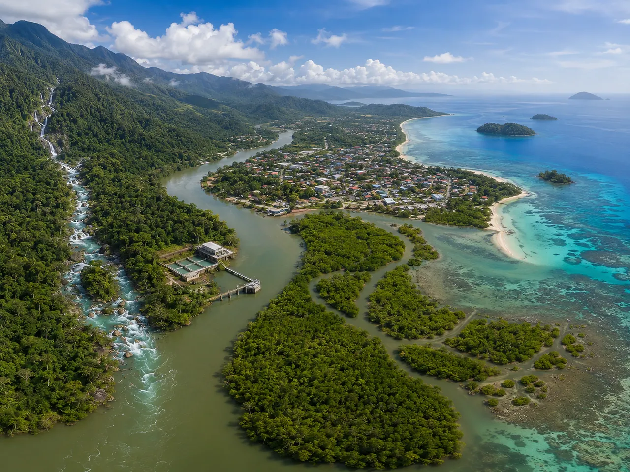
From the Heart of Borneo, through the Sangkulirang–Mangkalihat Karst Geopark, to the Coral Triangle Protecting Rivers, Securing Clean Water, Sustaining Life
“Every drop of water has a long journey. It begins in the mountains and forests, flows through rivers, sustains communities, and eventually reaches the sea. This journey connects nature and people within a single cycle of life.”
185,000+
people
depend on services whose raw-water sources are connected to the Berau–Kelai watershed
±30 million tonnes
coal & CPO
each is cited as moving through the river corridor annually in the initial concept document
1 water corridor
ridge-to-reef
connecting forests, rivers, drinking-water systems, mangroves, and coral reefs
Upstream–Downstream
one governance system
integrating source-water protection with service continuity
Why It Matters
Water-service resilience begins before water reaches the intake.
Perumda’s raw water is part of a long ecological journey. Upstream disturbance, changing river discharge, flooding, drought, sedimentation, and pressures along the river corridor can affect raw-water quality, treatment costs, and service continuity.
Drought & Reduced River Flow
Changing rainfall patterns can reduce raw-water availability and increase the risk of production disruption.
Flooding & High Turbidity
Extreme rainfall and erosion increase sediment loads, place additional pressure on treatment processes, and may disrupt intake and treatment-plant operations.
Upstream–Downstream Ecosystem Pressure
Separate watershed and coastal governance can sever the link between source-water protection and downstream ecosystem recovery.
Integrated Water Journey
From the Heart of Borneo to the Coral Triangle.
Follow ten connected stages: the Heart of Borneo, karst landscape, main rivers, Perumda water system, community homes, mangroves, the Derawan Islands, and the Coral Triangle.
01
01 · Landscape Source
Heart of Borneo
Headwaters · Water-Security Buffer
The water journey begins in the upstream landscape, where forest cover, recharge areas, springs, and surface flows are protected before water enters the river system.
Climate risk
Land-cover change, fire, erosion, changing rainfall patterns, and declining landscape water-retention capacity.
Programme response
Catchment protection, land-cover monitoring, rehabilitation of priority areas, and collaboration with upstream communities.
02
02 · Karst Landscape
Sangkulirang–Mangkalihat Karst Mountains
Karst · Natural Recharge System
The karst landscape is positioned as an important link in the water-flow story, connecting rock formations, recharge, springs, and flows toward the river basin.
Climate risk
Loss of land cover, disruption of recharge zones, erosion, sedimentation, and changes in flow quality and continuity.
Programme response
Recharge-zone protection, vulnerability mapping, spring monitoring, control of high-risk activities, and conservation education.
03
03 · Upper Rivers
Segah River & Kelay River
Tributaries · Upstream Water Corridors
Flows from upstream landscapes are gathered through the Segah and Kelay rivers, carrying water, sediment, and the influence of activities across the watershed.
Climate risk
Flow variability, flooding, drought, high turbidity, pollution, and sedimentation.
Programme response
Water-quality and flow monitoring, pollution-source control, stronger early warning, and coordinated watershed management.
04
04 · Main River
Berau River
Main River · Upstream–Downstream Connector
The Berau River connects the flow toward urban areas, the drinking-water system, estuary, and coast within one ridge-to-reef continuum.
Climate risk
Extreme turbidity, flow changes, pollution, sedimentation, flooding, and raw-water quality disruption.
Programme response
Integrated monitoring, pollutant-load control, cross-sector governance, and river-condition communication protocols.
05
05 · Raw-Water Abstraction
Perumda Intake
Intake · Entry Point to the Water System
Raw water enters the Perumda system through the intake and is pumped toward the treatment plant according to operational capacity and conditions.
Climate risk
Debris and sediment, changing water levels, turbidity spikes, pump failure, power interruption, and restricted operational access.
Programme response
Intake maintenance, pump and power redundancy, water-level monitoring, routine cleaning, and emergency procedures.
06
06 · Water Treatment
Water Treatment Plant
Treatment · From Raw Water to Clean Water
At the treatment plant, raw water is processed and its quality controlled before being conveyed to reservoirs and the distribution network.
Climate risk
High turbidity, changing chemical demand, capacity constraints, power disruption, and equipment failure.
Programme response
Process and quality control, chemical reserves, equipment maintenance, real-time monitoring, and operational continuity planning.
07
07 · Drinking-Water Service
Community Homes
Service · Clean Water Delivered to Customers
Clean water is distributed through the network to household connections so communities receive safe, reliable, and sustainable service.
Climate risk
Low pressure, leakage, pipe damage, power disruption, demand surges, and unequal service continuity.
Programme response
NRW and DMA control, pressure monitoring, rapid repairs, alternative supply, disruption communications, and priority support for vulnerable groups.
08
08 · Estuary Ecosystem
Mangroves
Delta · Natural Coastal Buffer
After passing river and settlement areas, the flow reaches the estuary and interacts with mangrove ecosystems that provide an ecological buffer.
Climate risk
Coastal erosion, mangrove loss, sedimentation, pollution, salinity change, and sea-level rise.
Programme response
Mangrove restoration, community-based monitoring, waste and sediment control, and stronger blue-carbon initiatives.
09
09 · Coastal Islands
Derawan Islands
Islands · Coastal Living Space
Land-based flows reach island waters where water quality, sediment, coastal activities, and ecosystem health are closely connected.
Climate risk
Sedimentation, marine litter, ocean warming, tourism pressure, habitat damage, and changing water quality.
Programme response
Integrated coastal management, waste control, water-quality monitoring, visitor education, and collaboration with island communities.
10
10 · Marine Ecosystem
Coral Triangle
Reef · Final Ridge-to-Reef Destination
The Coral Triangle completes the water-flow story, showing how upstream, river, water-service, estuary, and coastal management contribute to marine ecosystem health.
Climate risk
Ocean warming, coral bleaching, sedimentation, pollution, habitat damage, and use pressure.
Programme response
Coral-reef conservation, monitoring of land-based impacts, area management, public education, and collaborative finance.
Programme Approach
Six pillars working as one integrated system.
Governance
Multi-Stakeholder Watershed Forum
A cross-sector coordination platform bringing together government, academia, business, communities, media, and development partners.
Integration
Connected Upstream and Downstream
Integrated watershed management upstream is connected with integrated coastal management downstream.
Operations
Reliable Drinking-Water System
Strengthening intakes, treatment plants, reservoirs, distribution networks, energy, chemicals, disruption communications, and service-recovery plans.
Finance
Self-Sustaining Finance Instruments
Developing financing mechanisms for channel maintenance, upstream restoration, sediment control, and forum governance.
Participation
Communities as Equal Partners
Mobilising local assets and knowledge while supporting performance-based ecosystem-service payments for catchment stewards.
Ecosystem
Blue Carbon as Added Value
Mangrove and seagrass restoration in the Berau Delta is linked to protection of downstream coastal areas and coral reefs.
Programme Documentation
Climate resilience activity gallery.
Documentation of field activities, coordination, education, conservation, source-water monitoring, and service-strengthening initiatives of Perumda Air Minum Batiwakkal Berau.
Intended Outcomes
Water services better prepared for a changing climate.
Better-Protected Water Sources
Catchment areas, river quality, and buffering ecosystems are managed under shared priorities.
More Adaptive Operations
Intakes, treatment plants, energy, chemicals, reservoirs, and networks are prepared for extreme-weather scenarios.
Faster Service Recovery
Service priorities, public communications, alternative supply, and recovery stages are defined before a crisis occurs.
Measurable Collaboration
The roles of government, communities, businesses, academia, and conservation partners are linked to outcome indicators.
Foundation
Grounded in data, policy, and tested precedents.
Tarya et al. (2015)
The initial concept cites this study as scientific evidence linking Berau River sediment with coastal-water conditions around the Derawan Islands.
Berau–Kelai River Basin Water Resources Plan · PUPR (2021)
The initial concept cites 4,430 hectares as a restoration priority within 88,219 hectares of critical land in the Berau–Kelai watershed.
Minister of PUPR Decree No. 426/2021
Cited as a legal basis for the Berau–Kelai River Basin Water Resources Management Coordination Team.
South Kalimantan Regional Regulation No. 18/2006
Cited as a legal and operational precedent for river-traffic levies on the Barito River, South Kalimantan.
Figures, partner nomenclature, and references on this page follow the initial Ridge-to-Reef concept document and should be verified before official publication.
Built Together
Cross-sector collaboration from ridge to reef.
Looking Ahead
From Berau, for Indonesia.
Berau encompasses both the tropical rainforests of the Heart of Borneo and coral-reef coasts within the Coral Triangle. The programme positions Perumda as a connector between raw-water source protection, reliable drinking-water systems, and downstream ecosystem recovery under one governance framework.
“Berau’s rivers connect the Heart of Borneo with the Coral Triangle—this programme governs that connection, with communities as the rightful owners of its future.”